Site Data-to-Park Options
Landscape & urban design · Dubai · competition entry
A browser studio that pulls a real site's data, models it in 3D, generates scored park layouts and logs every AI step — built for a municipal design competition.
Context
The brief carried a twist: the jury wanted an AI Methodology Report alongside the design, so every generated option had to be traceable to its inputs. The usual toolchain — GIS export, CAD, a rendering package, a chat window — produces a proposal but not a record.
- Site context (buildings, heights, roads, footpaths) had to be assembled by hand from several sources
- Alternatives were drawn one at a time, so there was never a fair comparison
- Shade and heat — the design constraint that matters most in a 47 °C August — were checked late, by eye
- Nothing recorded which decisions the AI had influenced and how
Outcome
6steps, locate to present
- Site context went from a day of assembly to a fetch
- Shade became a design input at generation time instead of a late check
- PLACEHOLDER — add the competition outcome when known
What we built
A six-step workflow in the browser — Locate, Extract, Model, Generate, Evaluate, Present — where each step is a module registered in one place and consumes the previous step's artefact. Search a location or draw the plot; the tool pulls buildings, roads and paths from OpenStreetMap, infers building heights with provenance, and writes a layered CAD plan exportable as DXF.
A 3D context model with extruded buildings, a sun slider and shadows, and a SketchUp-style toolset — draw, push/pull, offset, section plane, tape, undo — so the team could sketch in the same place the analysis runs.
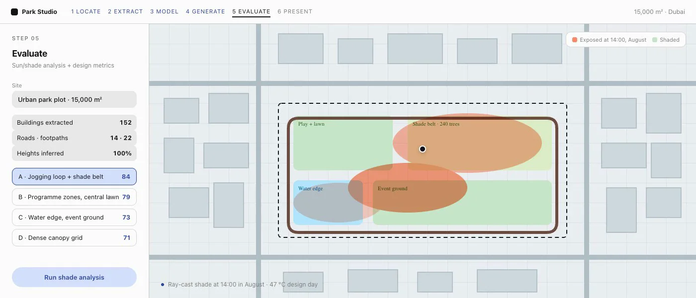
A seeded generative engine that produces four scored alternatives (a jogging loop, programme zones, a shade belt) from the site's constraints, and an evaluation step with a ray-cast shade heatmap, wind rose, annual solar radiation and sky-view factor from ERA5 climate data. Exports: PNG, DXF, a Markdown design report, and the project as JSON.
An append-only AI-usage log, written for the methodology report the competition required, plus a research pass that answered 45 questions about the brief with eight parallel research agents before design started.
What stuck
- Real data first: every option sits on the actual site, not a drawing of it
- Alternatives are generated together and scored the same way, so the comparison is honest
- The AI log is a by-product of using the tool, not a report written afterwards
Snapshot
- Client profile
- Architecture and engineering team entering a municipal AI park-design challenge
- Engagement
- Catalyst — competition tool, then a feature roadmap
- Timeline
- Built 11–19 July 2026; roadmap locked 11 August
- Scale
- 13 packages, ~12,000 lines, 5 architecture decisions, 45 research questions answered
- Scope
- Site location, GIS extraction, 3D context, generative layouts, shade and climate analysis, exports, AI-usage log